Construction Drone Deliverables Explained: Orthomosaics, DSMs, DTMs and Point Clouds
Part of the Aerial Decisions Construction Drone Intelligence Series
When a drone completes a mapping mission over a commercial construction or civil engineering project, the photographs from the flight are only the beginning.
Photogrammetry software can turn those overlapping images into several different types of project data. The most common deliverables include:
- Orthomosaics
- Digital Surface Models (DSM)
- Digital Terrain Models (DTM)
- Point clouds
Surveyors, engineers and reality-capture professionals may know these terms well. However, project executives, owners, project managers and other construction stakeholders may not know exactly what each one means.
More importantly, these deliverables don’t all answer the same questions.
Therefore, understanding the differences can help a project team choose the information it actually needs instead of creating data simply because the technology can produce it.
Start With the Raw Material: Drone Imagery
During a photogrammetry mission, a drone captures a large number of overlapping photographs while following a planned flight path.
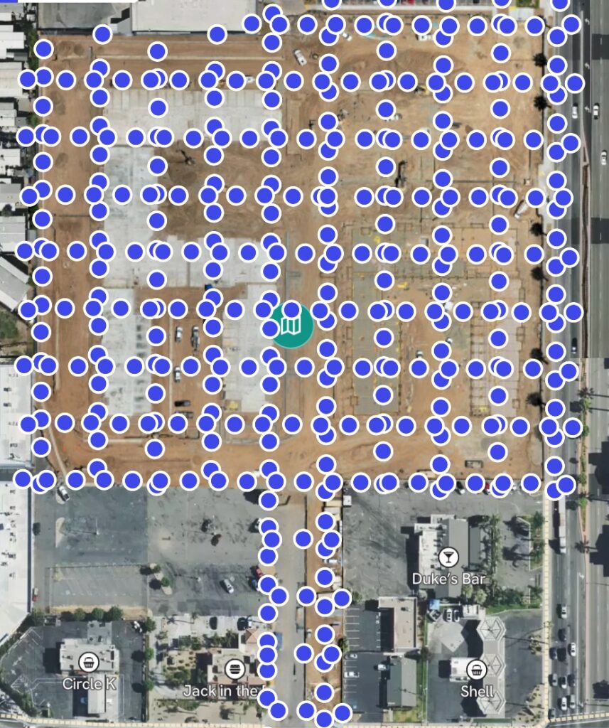
Next, photogrammetry software looks for common features that appear across multiple photographs. It uses the changing camera perspectives to calculate the shape and position of objects on the site.
As a result, the software can turn the original photographs into several useful mapping products.
Think of the photographs as the raw material.
The orthomosaic, DSM, DTM and point cloud then provide different ways to view and analyze the same construction site.
Let’s look at each one.
1. What Is an Orthomosaic?
An orthomosaic combines many aerial photographs into one continuous overhead image of the project.
At first glance, it may look like a very high-resolution satellite image. However, there is an important difference.
Photogrammetry software corrects much of the distortion caused by camera angle and terrain. It then combines the individual photographs into an image with a consistent scale, assuming the mapping workflow provides the required positional accuracy.
As a result, construction teams can use an orthomosaic to understand the entire project in context.
Construction teams may use an orthomosaic for:
- Progress documentation
- Site logistics
- Laydown areas
- Access and egress
- Utility work
- Equipment locations
- Material staging
- Plan overlays
- Month-over-month comparisons
In other words, the orthomosaic gives the team a detailed visual record of the site at a specific point in time.
Common orthomosaic file types
GeoTIFF (.tif or .tiff)
A GeoTIFF combines an image with geographic location information. Therefore, GIS and mapping applications can place it in the correct location.
JPEG (.jpg)
A JPEG works well for reports, presentations and easy sharing when the recipient doesn’t need the geographic data stored in a GeoTIFF.
Depending on the client’s workflow, the mapping team may also create other web-based or tiled image formats.
2. What Is a Digital Surface Model?
A Digital Surface Model, or DSM, shows the elevation of the surfaces captured by the drone.
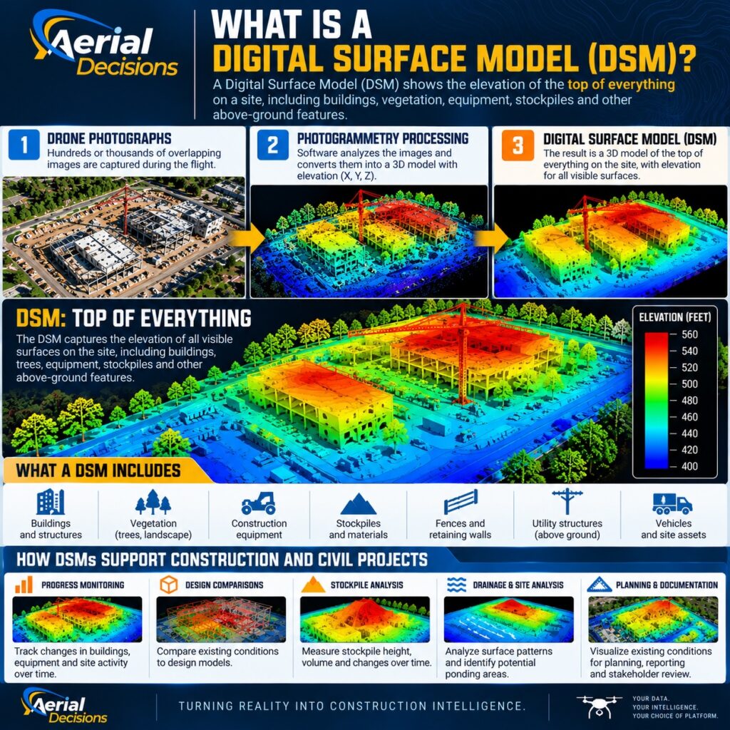
The word surface is important.
A DSM doesn’t show only the ground. Instead, it can include the tops of:
- Buildings
- Construction equipment
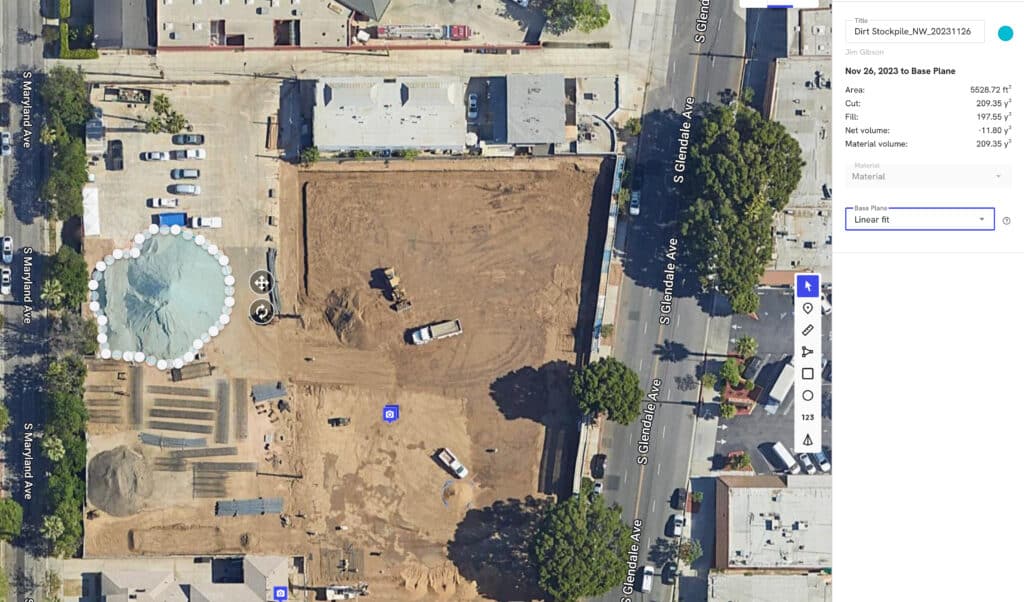
- Stockpiles
- Vegetation
- Materials
- Other above-ground features
A simple way to think about it is this:
A DSM shows the top surface of what the drone captured.
Because it includes elevation, a DSM can answer questions that a two-dimensional orthomosaic cannot.
Construction teams may use a DSM for:
- Elevation visualization
- Surface analysis
- Stockpile evaluation
- Drainage observations
- Understanding changes in site conditions over time
For example, an orthomosaic may show where a stockpile sits. A DSM, however, also adds information about its height and shape.
Common DSM file types
Teams commonly deliver a DSM as a georeferenced raster file such as:
GeoTIFF (.tif or .tiff)
Additionally, some engineering or GIS workflows may require other elevation-grid formats.
3. What Is a Digital Terrain Model?
A Digital Terrain Model, or DTM, focuses on the underlying ground or bare-earth surface.
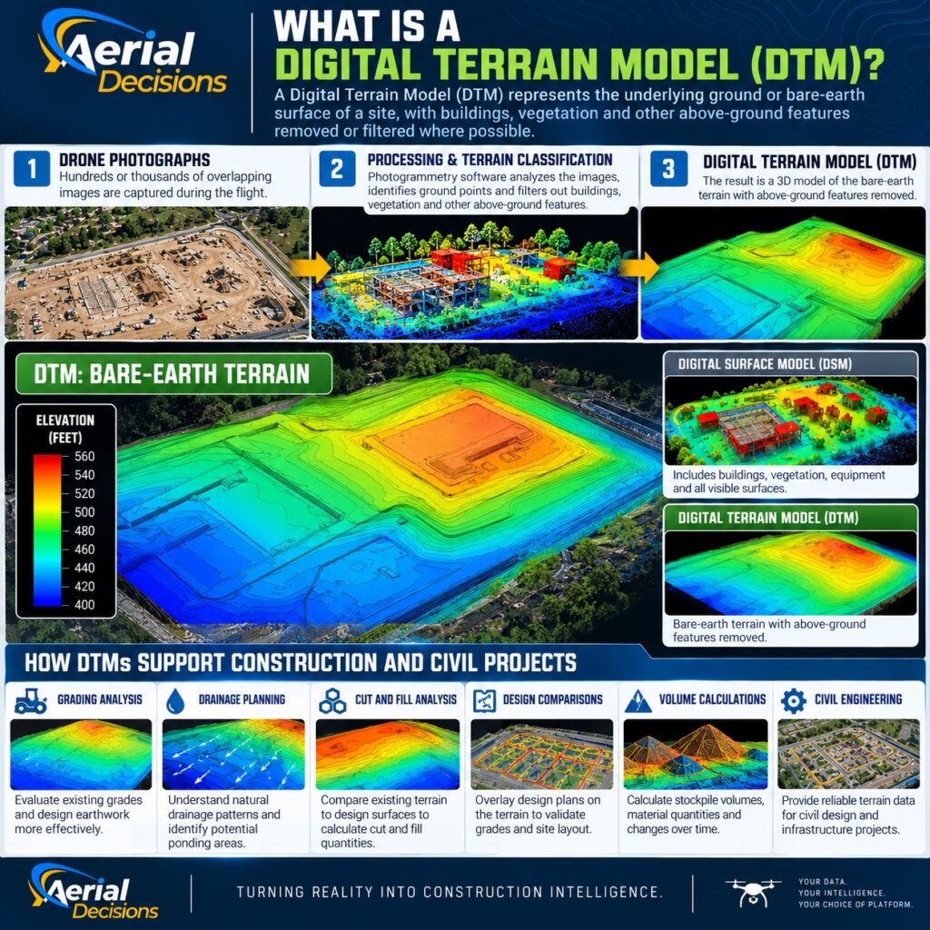
This distinction matters because a DTM and DSM serve different purposes.
A DSM asks:
What is the elevation of the surfaces we captured?
A DTM attempts to answer:
What is the elevation of the underlying terrain?
To create a useful DTM, processing software must identify which points represent the ground. Then it can filter out or remove non-ground objects where the data and conditions allow.
Those objects may include buildings, vegetation, equipment and construction materials.
Consequently, a DTM can become especially useful for civil engineering and earthwork applications.
Construction and engineering teams may use a DTM for:
- Grading analysis
- Drainage evaluation
- Terrain modeling
- Earthwork analysis
- Cut-and-fill workflows
- Comparison with design surfaces
Common DTM file types
Like a DSM, teams often deliver a DTM as a geospatial elevation file such as:
GeoTIFF (.tif or .tiff)
However, the final file type should match the engineering, CAD or GIS software that will use the data.
4. What Is a Point Cloud?
A point cloud works very differently from an orthomosaic.
Instead of creating one continuous image, photogrammetry software generates a large collection of individual points in three-dimensional space.
Each point contains coordinates that describe its position.
Together, millions of these points create a detailed 3D representation of the site.
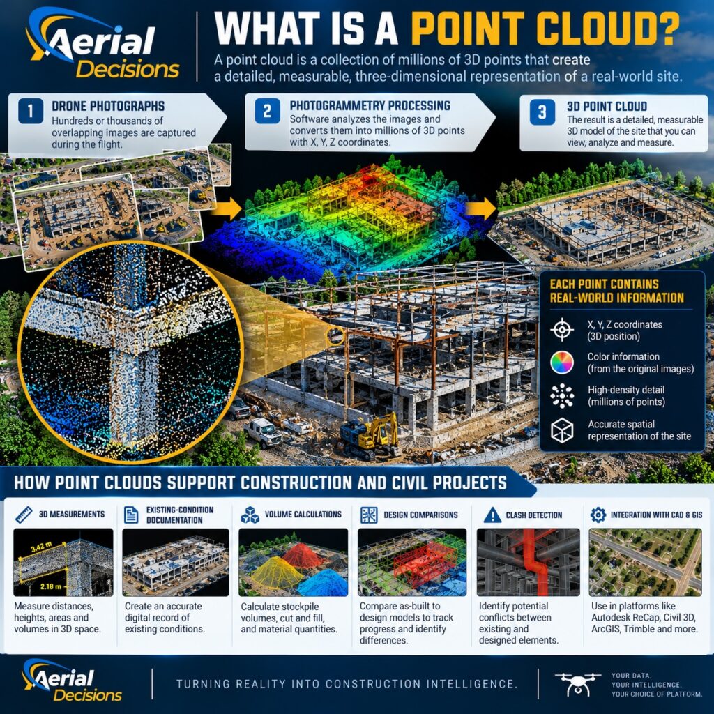
As a result, construction, engineering and reality-capture professionals can work with the site as three-dimensional spatial data, not simply as a photograph.
Point clouds can support:
- 3D measurements
- Surface generation
- Existing-condition documentation
- Elevation analysis
- Volumetric analysis
- Design comparisons
- CAD, GIS and reality-capture workflows
Common point-cloud file types
LAS (.las)
LAS is a widely used standard format for storing point-cloud data.
LAZ (.laz)
LAZ compresses LAS data. Therefore, it usually creates a much smaller file while preserving the point-cloud information.
Depending on the software and workflow, teams may also encounter formats such as PLY or XYZ.
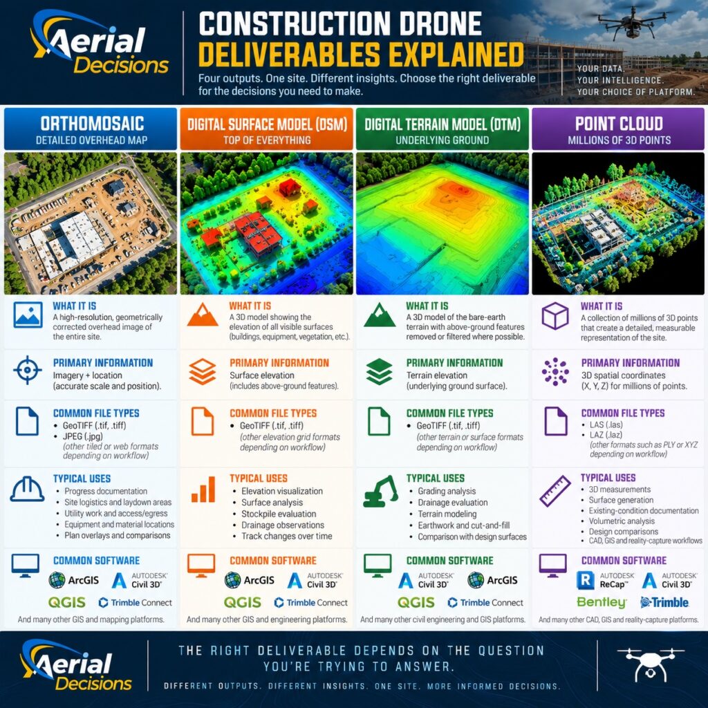
Orthomosaic vs. DSM vs. DTM vs. Point Cloud
Here’s a simple way to remember the difference:
| Deliverable | Think of it as | Primary information |
|---|---|---|
| Orthomosaic | Detailed overhead map | Imagery + location |
| DSM | Top of everything | Surface elevation |
| DTM | Underlying ground | Terrain elevation |
| Point Cloud | Millions of points creating a 3D site | Detailed 3D geometry |
However, the most important point is this:
The best deliverable depends on the question you’re trying to answer.
For example, if the team simply needs to see the location of materials across the site, an orthomosaic may provide enough information.
On the other hand, if the team needs elevation data, a DSM or DTM may make more sense.
Meanwhile, detailed 3D measurements may require the point cloud.
Therefore, choosing the deliverable should start with the business or engineering question, not the drone.
Case Study: Mapping a Site for Civil Engineering Use
Consider a large site that a civil engineering team needs to evaluate for planning, design or future development.
A single drone mapping mission can support several outputs.
First, the orthomosaic provides a detailed visual overview of existing conditions.
Next, the DSM adds elevation information for the surfaces across the property.
A properly developed DTM can then provide a clearer representation of the underlying terrain for appropriate terrain analysis.
Finally, the point cloud gives the team detailed three-dimensional information for additional measurement, modeling or reality-capture workflows.
Although these may sound like four separate products, they all come from the same physical site.
Each one simply answers a different type of question.
Therefore, the project team should select deliverables based on how engineers, surveyors, project managers or other professionals plan to use the information.
There is another important consideration.
When a project requires survey-grade or engineering-grade accuracy, the team must design the capture, control, processing and validation workflow around that requirement from the beginning.
The file format alone does not make a dataset survey-grade.
The File Format Matters—But So Does Where the Data Goes
Choosing the correct output involves more than selecting between GeoTIFF, LAS and LAZ.
Project teams may need to move drone data into platforms such as:
- Autodesk Civil 3D
- ArcGIS
- Trimble Connect
- Pix4D
- Other construction, GIS and engineering systems
Therefore, before creating the final deliverable, ask three questions:
Where does the data need to go?
Who needs to use it?
What do they need to do with it?
Those answers should guide both the type of deliverable and the file format.
For that reason, we believe construction drone programs should remain platform agnostic whenever possible.
The client should not have to redesign its workflow around the drone provider’s preferred software.
Instead, the drone data should fit the construction team’s existing workflow.
How This Connects to Construction Intelligence
In the previous installment of our Construction Drone Intelligence Series, we introduced this progression:
CAPTURE → COMPARE → QUANTIFY → VALIDATE → DECIDE
The deliverables we’ve discussed fit directly into that process.
First, an orthomosaic provides visual and spatial context.
Next, a DSM adds information about surface elevation.
Meanwhile, a DTM helps describe the underlying terrain.
Finally, a point cloud provides detailed three-dimensional geometry.
From there, project teams can compare datasets over time.
They can also measure changes, evaluate quantities and review the information alongside plans, schedules or other project data.
As a result, drone mapping begins to move beyond simple documentation.
It becomes another source of construction intelligence.
Frequently Asked Questions
Do I need an orthomosaic, DSM, DTM and point cloud on every construction project?
No.
In fact, creating every possible output may only produce more data for the team to manage.
Instead, start with the question the project needs to answer. Then select the deliverable that provides the right information.
What’s the biggest difference between a DSM and a DTM?
A DSM generally shows the elevation of visible surfaces, including buildings, vegetation, stockpiles and other objects.
A DTM, on the other hand, focuses on the underlying ground.
Therefore, the best choice depends on whether the project team needs information about visible surfaces or bare-earth terrain.
Is an orthomosaic just a large aerial photograph?
No.
Photogrammetry software creates an orthomosaic from many overlapping aerial photographs. During processing, the software corrects geometric distortions and combines the photographs into one continuous overhead image.
As a result, an orthomosaic offers much more spatial value than a single aerial photograph.
Can I open a GeoTIFF like a normal photograph?
Some applications can display a GeoTIFF as an image.
However, its biggest advantage is the geographic information stored with the image. Compatible GIS and mapping software can use that information to place the image in its correct location.
Why would I use LAZ instead of LAS?
LAZ compresses LAS point-cloud data.
Therefore, LAZ files are often easier to store, transfer and share, especially when a point cloud contains millions of points.
Can these files be used in Civil 3D or GIS?
Yes, many drone-derived datasets can become part of engineering and GIS workflows.
However, the correct import process depends on the software, coordinate system, file type and intended use.
For that reason, the drone provider should understand the client’s downstream workflow before creating the final files.
Does a drone-generated DTM replace a professional survey?
No.
A drone-derived DTM can provide valuable terrain information. However, generating a terrain model does not automatically make it a legally authoritative survey product.
When a project requires professional surveying, the appropriate licensed professionals and accuracy controls should remain part of the workflow.
How accurate are drone mapping deliverables?
There is no single answer.
Accuracy depends on many factors, including:
- Aircraft and camera
- Flight altitude
- Image overlap
- Image quality
- Ground control
- RTK or PPK methodology
- Processing workflow
- Coordinate system
- Terrain
- Validation procedures
Therefore, teams should establish the required accuracy before designing the mission.
The Executive Takeaway
Don’t start a construction drone mapping project by asking:
“What deliverables can the drone produce?”
Instead, ask:
“What are we trying to understand?”
Then work backward.
If the question is primarily visual, an orthomosaic may provide what you need.
If elevation matters, consider a DSM or DTM.
If detailed three-dimensional information matters, a point cloud may become part of the solution.
In many cases, teams may use several deliverables together.
Ultimately, the goal isn’t to produce more drone data.
The goal is to produce the right data for the decision.
Watch the Video
Want the quick version?
Watch “Construction Drone Deliverables Explained: Orthomosaics, DSMs, DTMs and Point Clouds” on the Aerial Decisions YouTube channel.
WordPress recommendation: Embed the YouTube video directly in this section once you publish it. That gives readers the choice to watch or continue reading while keeping the Vlog and blog connected as one piece of the Construction Drone Intelligence Series.
Part of the Construction Drone Intelligence Series
This article is part of the Aerial Decisions Construction Drone Intelligence Series, an educational series that explores how drone technology, photogrammetry, reality capture, software and AI can turn aerial data into practical intelligence for commercial construction and civil engineering.
Our continuing framework is:
CAPTURE → COMPARE → QUANTIFY → VALIDATE → DECIDE
Because the goal isn’t simply to capture the site.
It’s to turn the right data into information that helps construction professionals make better decisions.
YOUR DATA. YOUR INTELLIGENCE. YOUR CHOICE OF PLATFORM.
Disclaimer
Drone mapping and data services provided by Aerial Decisions are intended for visual documentation, progress tracking, and general measurement purposes only. These services do not replace licensed land surveying, boundary determination, or engineering-grade deliverables.
From The Editor:
Do you need to hire a professional drone service provider for your project? To speak to an aerial data specialist, fill out a form, email us or for even faster response times, give us a call at (833) FLY-4YOU or (833) 359-4968. Check out our transparent pricing and watch this space as we expand on the above topics and more over the coming weeks and months.
If you like this post, feel free to click the share button at the bottom of the page. We appreciate you helping us by spreading the content we share on our blog.

Showcase Your Company on the Drones and Construction Podcast! If you’d like to be a featured guest on our podcast, send us an email: info@aerialdecisions.com and one of our crew will get right back to you to share the details.
About Aerial Decisions
YOUR DATA. YOUR INTELLIGENCE. YOUR CHOICE OF PLATFORM.
Aerial Decisions is a Construction Intelligence company transforming jobsite reality into actionable data that helps contractors, owners, engineers, and municipalities make better-informed decisions.
We combine professional aerial and reality capture with advanced data processing, visualization, analytics, and AI-optimized technology to create a clear, measurable view of what is happening across a project.
Our platform-agnostic approach means your data isn’t locked into a single software ecosystem. We capture, process, visualize, analyze, and integrate construction intelligence into the tools and workflows your teams already use.
Supported by a network of FAA-certified, insured professionals and purpose-built technology, Aerial Decisions provides the visibility and intelligence project teams need—from pre-construction through completion.
Capture → Process → Visualize → Analyze → Integrate