by Jim Gibson
As a drone pilot, I’ve always been fascinated by the incredible perspective a drone provides. It’s like having a bird’s eye view with the ability to freeze time and dissect every detail below. But beyond the stunning visuals, drones are powerful tools for creating maps that are more than just pretty pictures—they’re accurate, data-driven representations of the world. Let me guide you through the world of drone mapping, keeping it simple and fun.
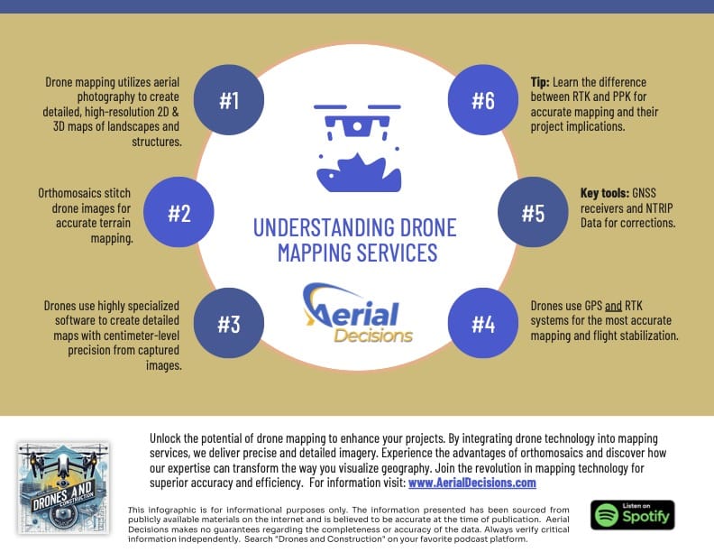
What Is Drone Mapping?
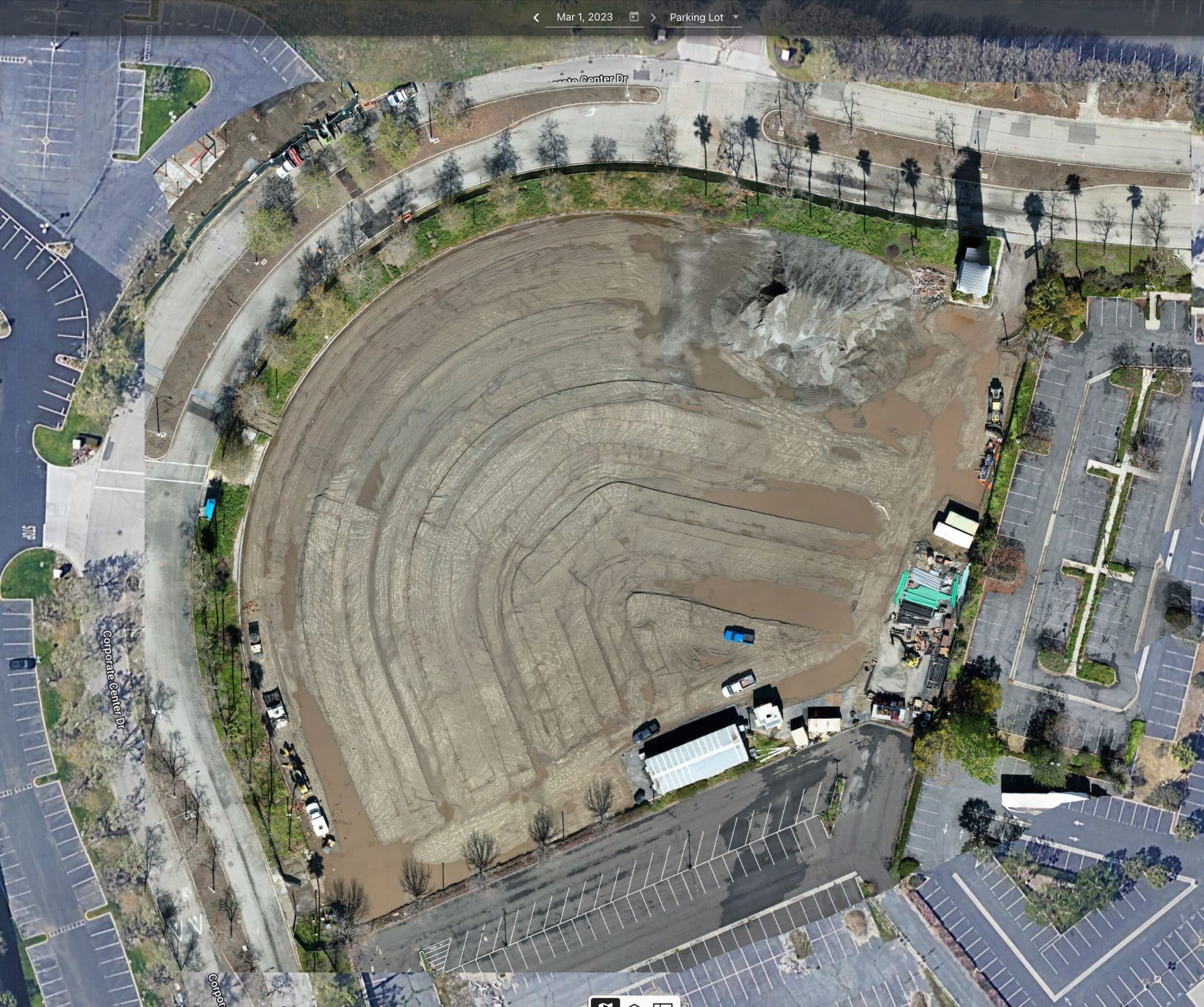
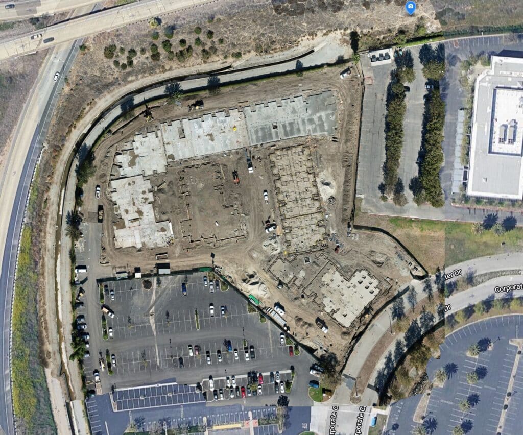
Imagine you’re putting together a jigsaw puzzle, but instead of individual pieces, you have photos taken from the sky. Drone mapping stitches these photos together to create a seamless, detailed picture of the land below. This is what we call an orthomosaic. It’s like a high-tech quilt made from aerial images, corrected for perspective and distortion, so everything lines up perfectly.
Drone mapping isn’t just about making maps; it’s about precision and accuracy. Whether you’re in construction, agriculture, or environmental monitoring, a well-made map is like a crystal ball, revealing insights that help you make better decisions.
What Are Orthomosaics, and Why Are They Important?
Orthomosaics are the bread and butter of drone mapping. Think of them as the difference between a hand-drawn treasure map and a detailed GPS-enabled city map. While the treasure map might get you in the ballpark, the city map ensures you find the exact address.
These stitched-together images are incredibly accurate, allowing you to measure areas, calculate volumes, and even identify small changes over time. For example, in construction, orthomosaics help track progress and ensure everything is on track—literally and figuratively.
How Are Drone Maps Created?
Creating a drone map is like baking a cake. You need the right ingredients, tools, and a good recipe. The first ingredient is, of course, the drone. Most drones come with GPS systems that help them fly accurately and stay stable in the air. It’s like the autopilot on an airplane, ensuring a smooth ride. GPS alone, however, is like baking a cake without measuring the ingredients—it might look okay, but it won’t be precise.
This is where additional tools come in. Drones equipped with RTK (Real-Time Kinematic) modules are game-changers. RTK acts like a kitchen scale, measuring everything down to the gram. It provides real-time corrections to the drone’s position, ensuring centimeter-level accuracy. But even RTK isn’t enough without Ground Control Points (GCPs). These are like the landmarks on your treasure map, anchoring your data to the real world.
To make everything work together, you also need a GNSS receiver and, in most cases, access to an NTRIP (Networked Transport of RTCM via Internet Protocol) subscription. It’s a mouthful, I know, but think of NTRIP as your recipe’s secret ingredient—a little extra something that makes your map exceptionally accurate.
RTK vs. PPK: What’s the Difference?
RTK and PPK (Post-Processed Kinematic) are like two chefs with different cooking styles. RTK is all about instant results. It’s like cooking with a pressure cooker, delivering fast, accurate data corrections in real time. PPK, on the other hand, is more like slow cooking. You gather the data during your flight and process it later for even more refined accuracy.
Both methods have their strengths. RTK is ideal for real-time applications, while PPK shines when you need the highest level of precision. The choice between the two depends on your project’s needs, much like choosing between quick weeknight meals and a gourmet weekend feast.
A Word of Caution: Accuracy vs. Survey-Grade
Here’s a crucial point for drone pilots and service providers: avoid claiming that your maps are “survey-grade” unless you’re a licensed surveyor. It’s like calling a home-cooked meal a Michelin-starred dish. While your maps might be highly accurate, using the term “survey-grade” can lead to legal trouble with government agencies and professional surveyors. Instead, focus on highlighting your maps’ precision and practical applications.
Why Accuracy Matters
Accurate maps are more than just a nice-to-have; they’re the foundation for decision-making. Imagine a construction site where measurements are off by even a few inches. Those inches could translate into costly mistakes. With tools like RTK, PPK, and GCPs, we ensure our maps are as accurate as possible, providing our clients with reliable data they can trust.
Final Thoughts
Drone mapping is an incredible blend of art and science. It’s about taking raw data from the sky and transforming it into actionable insights. By understanding tools like RTK and PPK and embracing best practices, we can create maps that are not only accurate but also impactful.
To my fellow drone pilots, remember that accuracy is key, but honesty is just as important. Always communicate clearly about what your maps can and cannot do. And to anyone considering drone mapping services, know that you’re not just getting a map—you’re getting a tool to unlock the potential of your project.
Thanks for joining me on this journey into drone mapping. Whether you’re a seasoned pro or just starting out, I hope this has given you a clearer picture of what’s possible. Fly safe and map responsibly!
From The Editor:
Do you need to hire a professional drone service provider for your project? To speak to an aerial data specialist, fill out a form, email us or for even faster response times, give us a call at (833) FLY-4YOU or (833) 359-4968. Check out our transparent pricing at https://www.aerialdecisions.com/drone-photography-pricing/ and watch this space as we expand on the above topics and more over the coming weeks and months.
If you like this post, feel free to click the share button at the bottom of the page. We appreciate you helping us by spreading the content we share on our blog.

Showcase Your Company on the Drones and Construction Podcast! If you’d like to be a featured guest on our podcast, send us an email: info@aerialdecisions.com and one of our crew will get right back to you to share the details.
About Aerial Decisions
Aerial Decisions is a Los Angeles-based Drone Services Provider (DSP). We specialize in providing cutting-edge drone data collection combined with industry leading software solutions tailored for the commercial construction industry. Our mission is to optimize the way enterprise construction projects are managed by offering precise aerial photography, detailed data analysis, and innovative software tools through a network of FAA-certified and insured drone pilots. Aerial Decisions is not just a drone service provider; we are your strategic partner in commercial construction. Our hands-on approach to understanding your unique requirements and our dedication to excellence ensures that every flight and every data point is optimized for your success. Trust us to be the eyes in the sky that elevate your construction projects to new heights.

Founder | CEO at Aerial Decisions
Jim is the founder of Aerial Decisions and is an FAA Part 107 Certified Commercial Drone Pilot.He has spent the last 10 years building and leading world class sales teams for an industry leading digital marketing agency.Jim is widely recognized amongst his peers as a consummate full funnel digital marketing expert and a respected industry leader.
Equally adept as an entrepreneur, Jim has led start up organizations in a multitude of industries ranging from telecommunications to web based software services.In this latest adventure, Jim is leveraging his profound love of flying drones into a dynamic new start-up that he hopes one day becomes the standard bearer for drone flying advocacy across the globe.
Jim originally hails from Clearwater, Florida and currently lives in Glendale, California with his wife Diana and his lovable pup, Gunnar.
When Jim’s not flying drones: “You’ll catch me on the ice (or asphalt) playing beer league hockey or training for my next triathlon.Whether it’s on ice asphalt or in the water you’ll always find me on the move and rarely sitting still.
Latest posts by Jim Gibson (see all)
- Drones and Construction – The 2025 Outlook - February 8, 2025
- The Future of Business: Top 7 Commercial Drone Applications Across Key Sectors - January 19, 2025
- From Over-Ordering to Supplier Accountability: How Drones Redefine Stockpile Management - January 12, 2025