From Drone Data to Construction Intelligence
Why Capturing the Construction Site Is Only the Beginning
For years, the conversation around drones in commercial construction has largely focused on what drones can capture.
High-resolution photographs. Video. Orthomosaics. 3D models. Point clouds. Digital surface and terrain models.
All of those deliverables can provide tremendous value.
But as drone technology becomes more deeply integrated into construction workflows, a more important question is emerging:
What can we actually learn from all of this data?
That represents the next evolution of drones in commercial construction.
It is the transition from drone data collection to construction intelligence.
At Aerial Decisions, we believe the value of a drone program should ultimately be measured not by how much data it captures, but by whether that information helps construction professionals understand what is happening, identify what deserves attention, and make better-informed decisions.
That is the focus of this installment of our Construction Drone Intelligence Series.
The Evolution: From Capture to Decision
A drone can collect an extraordinary amount of information about a construction site in a relatively short period of time.
But capturing data is only the beginning.
The real opportunity develops when construction teams begin using that information as part of a repeatable intelligence workflow:
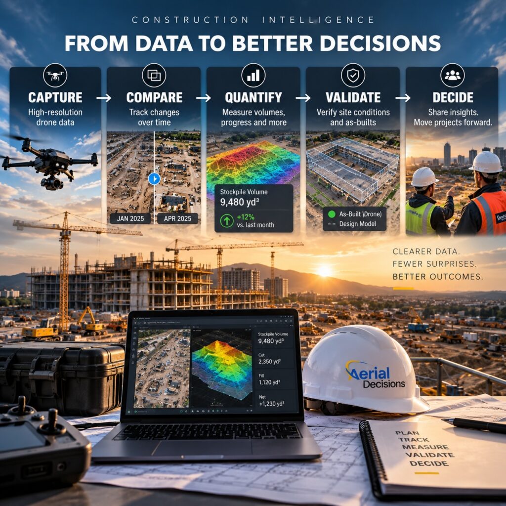
Each step adds another level of value.
CAPTURE
Create an accurate and repeatable visual record of current site conditions.
COMPARE
Evaluate current conditions against previous flights, plans, designs or other project information.
QUANTIFY
Where appropriate, use photogrammetry, point clouds, terrain models and other data to measure distances, areas, elevations, volumes and physical changes.
VALIDATE
Compare what is visible or measurable in the field against what was expected to occur.
DECIDE
Give the project team better information to determine what deserves attention and what action—or additional investigation—may be appropriate.
The drone is therefore not the intelligence.
It is the data acquisition layer that makes the intelligence possible.
The Power of Asking: “What Changed?”
Consider something as straightforward as a construction orthomosaic.
One orthomosaic provides a highly detailed, geometrically corrected view of the project at a particular point in time.
That’s useful.
But capture that same site consistently—using comparable flight parameters and a regular cadence—and something much more valuable begins to happen.
You create a visual history of the project.
Now the team can compare consecutive datasets and start asking:
What changed?
That seemingly simple question can reveal changes involving:
- Earthwork and grading
- Utility trenching and backfill
- Foundations and structural work
- Material staging and laydown areas
- Stockpile locations and quantities
- Equipment positioning
- Site access and haul routes
- Temporary facilities
- Drainage and ponding
- Traffic control
- Perimeter fencing and security
- Overall site organization and progress
Instead of depending solely on someone’s recollection of what the site looked like several weeks earlier, the team has an objective visual record.
And that can change the quality of the conversation.
Adding AI-Assisted Construction Intelligence
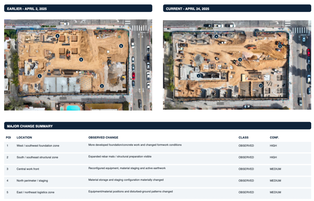
This is where artificial intelligence introduces another interesting layer.
A large commercial construction project can contain thousands of visual changes between consecutive drone missions.
A human can certainly compare two datasets.
The challenge is identifying which changes actually deserve attention.
AI-assisted analysis can help evaluate consecutive datasets and identify observable differences that might otherwise require considerable time to find manually.
The questions become increasingly useful:
What changed?
How much changed?
Is what we’re seeing consistent with what was expected?
What deserves a closer look?
Why might it matter?
What should the project team ask next?
That is very different from simply generating another drone report.
It begins turning visual documentation into construction intelligence.
AI Doesn’t Replace Construction Expertise
There’s an important distinction here.
AI should not be determining whether a construction project is being managed correctly.
Nor should drone technology replace the expertise of project managers, superintendents, engineers, surveyors or other construction professionals.
Instead, think of AI-assisted analysis as another set of eyes.
It can help professionals work through large amounts of visual information more efficiently and identify areas that may warrant additional investigation.
The technology identifies the observation.
Experienced construction professionals provide the context.
That distinction is critical.
Connecting Drone Intelligence to the Project Schedule
The next logical step is connecting observed field conditions with other sources of project information.
One of the most interesting opportunities is the project schedule.
Suppose a particular area was scheduled for grading during the previous month.
What does the visual record show?
If underground utility installation was scheduled to advance through a particular section of the site, is that progression visible?
If structural work was expected to move into another portion of the project, does the captured data appear consistent with that sequence?
Drone imagery alone should not be used to declare that a project is ahead or behind schedule.
But when visual observations are combined with scheduling information, they can provide project teams with another valuable source of context.
And that is where construction intelligence becomes much more powerful.
Going Deeper: Quantifying Change
Not every construction question can be answered from imagery alone.
That’s why different forms of drone data serve different purposes.
Progress photographs and video are excellent for documentation.
Orthomosaics provide spatial context across the entire project.
Digital surface models and digital terrain models introduce elevation information.
Point clouds provide detailed three-dimensional representations of site conditions.
Those datasets can support deeper analysis involving:
Stockpile volumes.
Cut-and-fill conditions.
Elevation changes.
Distances and areas.
Site-plan comparisons.
Physical progress over time.
The objective isn’t to produce every possible drone deliverable.
It’s to determine:
What information does the construction team need to make the decision in front of them?
Then capture and process the appropriate data to support it.
Case Study: Seeing a Construction Project Month Over Month
One of the ways we’ve been exploring this concept at Aerial Decisions is through recurring progress monitoring on an active multi-building commercial construction project.
Each month, the site is captured again using a repeatable aerial workflow.
Traditionally, those missions provide the project team with progress photographs, aerial imagery and an updated orthomosaic.
But the historical datasets create another opportunity.
Instead of looking only at the newest imagery, we can compare the current orthomosaic against the previous month’s capture.
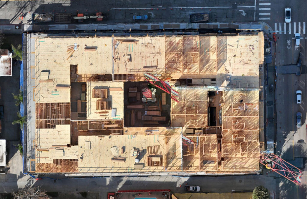
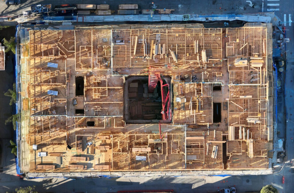
That allows us to examine visible changes in areas such as site logistics, material staging, structural progress, equipment locations, access routes and general construction activity.
We can then apply AI-assisted analysis to help identify and organize those observable changes into a Construction Intelligence Report.
The important distinction is that the report doesn’t attempt to tell the superintendent or project manager how to run the project.
Instead, it helps answer:
Here’s what appears to have changed.
Here’s where that change occurred.
Here’s something you may want to look at more closely.
And as additional datasets such as project schedules, terrain models or point clouds become available, the depth of that analysis can continue to increase.
That’s the progression from documenting a project to helping professionals interpret the project.
Four Practical Applications of Construction Drone Intelligence
This approach can support several recurring construction workflows.
Progress Tracking
Consistent aerial captures allow teams to visually compare physical progress across days, weeks or months and maintain a historical record throughout the project lifecycle.
Stockpile and Quantity Monitoring
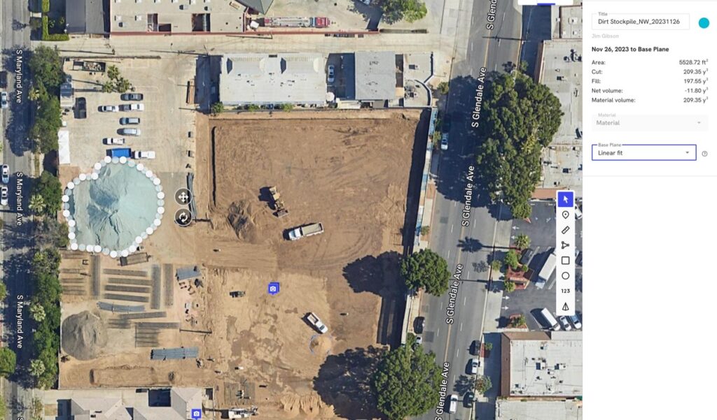
Photogrammetric datasets can support volume calculations and help teams understand how material quantities change over time.
Site Plan and Design Comparisons
Drone data can be overlaid with plans or other design information to provide additional context between documented field conditions and intended layouts.
Inspections and Documentation
High-resolution aerial imagery can document difficult-to-access areas, provide historical evidence of conditions and help direct human attention toward areas that deserve closer inspection.
The common denominator isn’t the drone.
It’s better access to useful project information.
Why This Matters to Owners and General Contractors
Construction projects already generate enormous amounts of data.
The problem is rarely a lack of information.
The problem is turning that information into something people can use.
For an owner, that may mean understanding project progress without visiting the site.
For a project executive, it may mean seeing meaningful changes across a large project more quickly.
For a project manager or superintendent, it may mean having an objective visual reference when discussing field conditions.
For an engineer or surveyor, it may mean having another dataset available to support professional analysis.
The value isn’t simply seeing more.
It’s understanding more.
The Executive Takeaway
The future of construction drones isn’t about taking better pictures.
And it isn’t about producing more data.
It’s about making existing project data more useful.
The progression looks something like this:
Capture the reality.
Compare the reality.
Quantify meaningful changes.
Validate those observations against other project information.
Give experienced professionals better information to make decisions.
And we believe that’s where commercial drone technology becomes considerably more valuable to the construction industry.
Frequently Asked Questions
What is construction drone intelligence?
Construction drone intelligence is the process of moving beyond basic aerial documentation and using drone-derived data to help identify, measure and interpret meaningful changes occurring across a construction project.
It can combine imagery, orthomosaics, photogrammetry, 3D models, point clouds and other project information to support better-informed construction decisions.
How is construction intelligence different from drone progress monitoring?
Progress monitoring primarily documents how a project changes over time.
Construction intelligence builds on that historical record by asking additional questions: What changed? How much changed? Is it consistent with expectations? What deserves attention?
Progress monitoring creates the record. Construction intelligence helps extract additional meaning from it.
Can AI determine whether a construction project is ahead or behind schedule?
Not reliably from aerial imagery alone.
AI can identify observable changes between datasets, but meaningful schedule analysis requires additional project context, including the actual project schedule and knowledge of construction sequencing.
AI should support experienced construction professionals—not replace their judgment.
Can drones measure stockpile volumes?
That’s construction intelligence.
Yes. Properly captured and processed photogrammetric data can be used to create three-dimensional surface information from which stockpile volumes can be calculated.
Accuracy depends on factors including flight planning, image quality, ground control, processing methodology and site conditions.
What’s the difference between an orthomosaic, DTM and point cloud?
An orthomosaic provides a geometrically corrected overhead image of the site.
A digital terrain model (DTM) represents ground elevations, typically with above-ground objects removed where processing permits.
A point cloud consists of millions of three-dimensional points representing captured surfaces and can support detailed measurement and spatial analysis.
Each dataset answers different construction questions.
Does construction drone intelligence replace a surveyor?
No.
Drone-derived data can be extremely useful to surveyors, engineers and construction professionals, but it should not be represented as replacing professional surveying services where licensed survey work is required.
The better model is augmentation: giving qualified professionals additional, timely information.
Does a construction company need a specific software platform to use drone intelligence?
Not necessarily.
The most effective approach is to determine how the construction team already works and deliver usable information into that environment whenever practical.
The objective should be useful construction intelligence—not forcing the client into a particular drone platform.
How often should a construction site be captured?
That depends on the project and the decisions the data needs to support.
Some projects benefit from weekly or bi-weekly capture, while others may be adequately documented monthly or at major construction milestones.
The key is consistency. Repeatable capture creates the historical datasets required for meaningful comparison.
Part of the Construction Drone Intelligence Series
From Drone Data to Construction Intelligence is part of Aerial Decisions’ ongoing Construction Drone Intelligence Series, exploring how drone technology, photogrammetry, reality capture, software, AI and construction workflows can transform aerial data into practical project intelligence.
Continue Reading – The Construction Drone Intelligence Series
- Part 1 – Drone Mapping in Commercial Construction
- Part 2 – Photogrammetry in Commercial Construction
- Part 3 – Drone Mapping Cost vs. Traditional Surveying
- Part 4 – Drone Construction Progress Tracking
- Part 5 – The ROI of Drones Isn’t the Flight—It’s the Decision
- Part 6 – Orthomosaic Mapping in Construction
- Part 7 – Construction Drone Deliverables Explained
- Part 8 – Procore + DroneDeploy: What It Means for Construction Drone Data
- Part 9 – Construction Drone Adoption Is Growing
Throughout the series, we’ll continue exploring the progression:
CAPTURE → COMPARE → QUANTIFY → VALIDATE → DECIDE
Because the objective isn’t the drone.
It isn’t the map.
And it isn’t another dashboard or PDF.
The objective is useful construction intelligence that helps people make better decisions.
YOUR DATA. YOUR INTELLIGENCE. YOUR CHOICE OF PLATFORM.

Disclaimer
Drone mapping and data services provided by Aerial Decisions are intended for visual documentation, progress tracking, and general measurement purposes only. These services do not replace licensed land surveying, boundary determination, or engineering-grade deliverables.
From The Editor:
Do you need to hire a professional drone service provider for your project? To speak to an aerial data specialist, fill out a form, email us or for even faster response times, give us a call at (833) FLY-4YOU or (833) 359-4968. Check out our transparent pricing and watch this space as we expand on the above topics and more over the coming weeks and months.
If you like this post, feel free to click the share button at the bottom of the page. We appreciate you helping us by spreading the content we share on our blog.

Showcase Your Company on the Drones and Construction Podcast! If you’d like to be a featured guest on our podcast, send us an email: info@aerialdecisions.com and one of our crew will get right back to you to share the details.
About Aerial Decisions
YOUR DATA. YOUR INTELLIGENCE. YOUR CHOICE OF PLATFORM.
Aerial Decisions is a Construction Intelligence company transforming jobsite reality into actionable data that helps contractors, owners, engineers, and municipalities make better-informed decisions.
We combine professional aerial and reality capture with advanced data processing, visualization, analytics, and AI-optimized technology to create a clear, measurable view of what is happening across a project.
Our platform-agnostic approach means your data isn’t locked into a single software ecosystem. We capture, process, visualize, analyze, and integrate construction intelligence into the tools and workflows your teams already use.
Supported by a network of FAA-certified, insured professionals and purpose-built technology, Aerial Decisions provides the visibility and intelligence project teams need—from pre-construction through completion.
Capture → Process → Visualize → Analyze → Integrate