by Jim Gibson
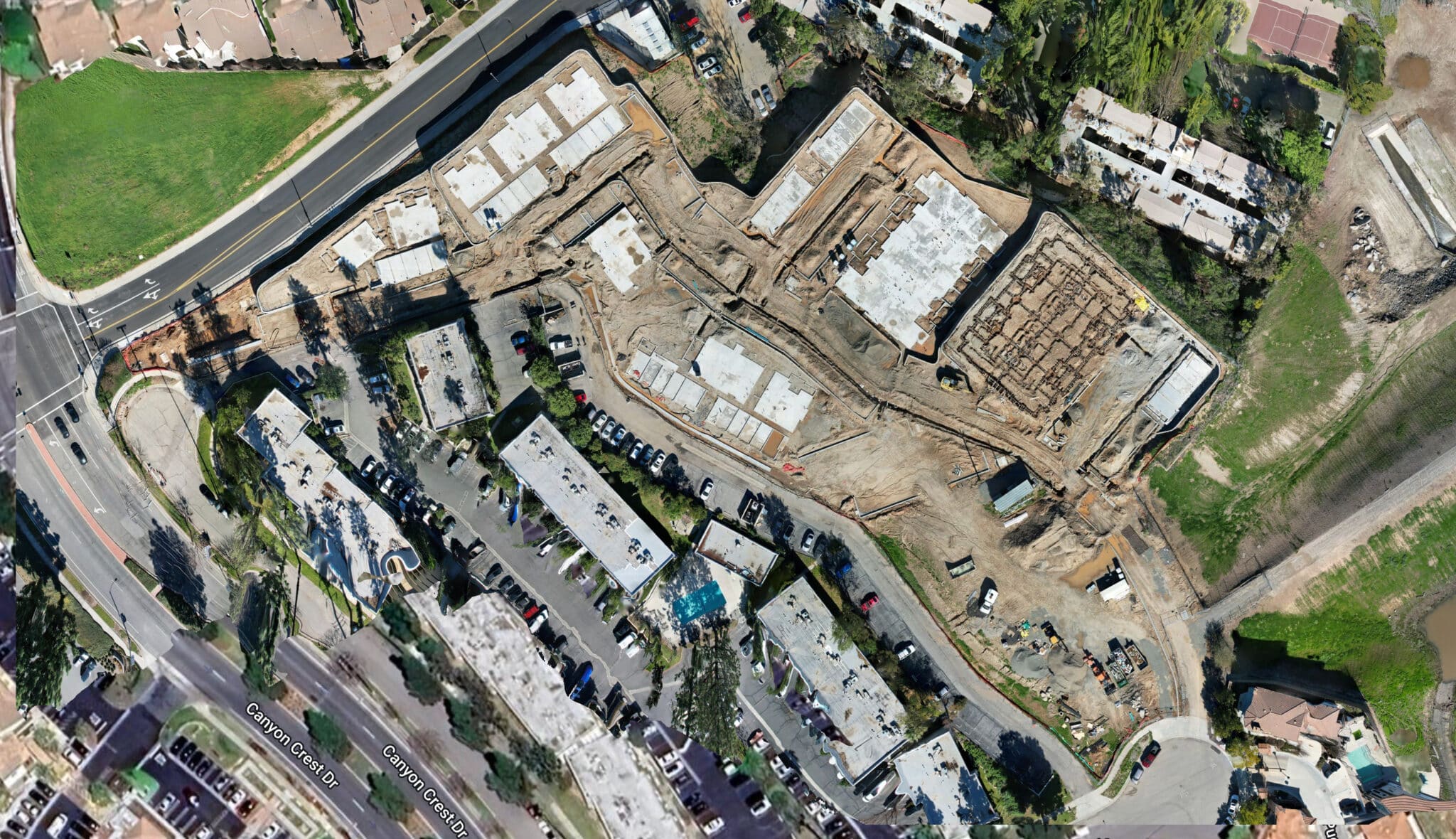
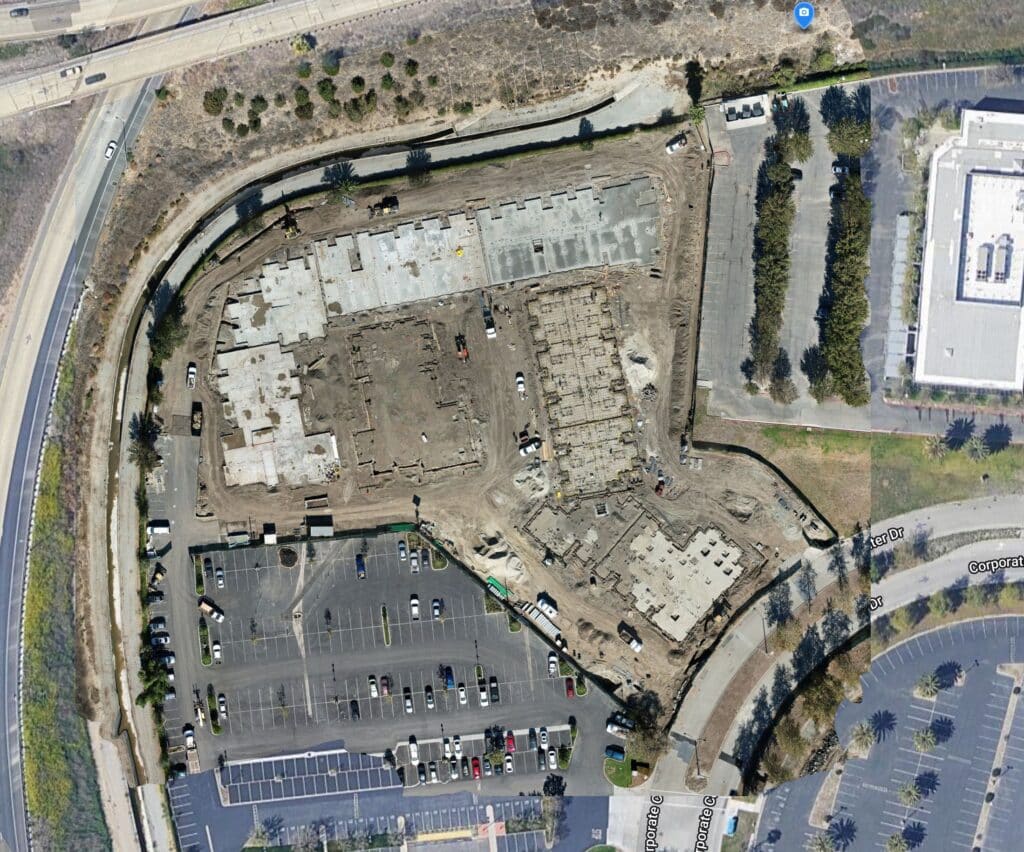
Drone Service Providers (DSPs) that specialize in data collection services for the commercial construction industry offer a vital tool for construction project managers: Orthomosaics. These images, sometimes called Ortho-Rectified Images, provide a bird’s-eye view of the ongoing commercial construction project, giving managers a clear and detailed overview of the site’s progress.
What is an Orthomosaic Image?
Let me break down what an orthomosaic is and why it’s different from a regular drone image.
Imagine you’re putting together a big puzzle, but instead of using puzzle pieces, you’re using thousands of tiny pictures taken from above by a drone. Each picture is like a puzzle piece, capturing a small part of the area you want to map, like a construction site.
How is an orthomosaic unique?
Now, let’s talk about what an orthomosaic does. An orthomosaic is like creating a giant, super-detailed map of that construction site by stitching all those little pictures together. It’s not just a simple collage; it’s more like creating a seamless, bird’s-eye view image that accurately represents every detail of the site, almost like you’re looking straight down from above.
Why an orthomosaic is different from a regular drone image:
- Accuracy: An orthomosaic corrects any distortions or variations caused by the angle and altitude of the drone, giving you a precise and accurate representation of the site. So, it’s like having a perfectly straight-down view, even though the drone might have been flying at an angle.
- Consistency: Every part of the orthomosaic fits together seamlessly, like pieces of a puzzle. This consistency is crucial for tasks like measuring distances, areas, and tracking changes over time on the construction site.
- Detail: Since an orthomosaic combines numerous images, it captures a tremendous amount of detail. You can zoom in and see things with much more clarity compared to a single drone image, making it incredibly useful for analyzing the site in depth.
So, in essence, an orthomosaic is like creating a super-accurate, detailed map of a construction site by piecing together thousands of drone photos. It helps you see the big picture while also allowing you to zoom in and examine the tiniest details, making it an invaluable tool for construction planning, progress tracking, and analysis.
Construction Project Managers love orthomosaics
For project managers, having a regular supply of ortho-rectified images is like having a constantly updated blueprint of the construction site. They can track progress, identify potential issues, and make informed decisions without needing to physically visit the site each time. This saves time and ensures that the project stays on track.
Why Construction Engineers love em’ too!
Engineers can utilize computational tools to analyze these images and manage day-to-day operations more efficiently. For example, they can use software to measure distances, areas, and volumes accurately. They can also overlay design plans onto the images to compare progress against the original blueprint, ensuring everything is being built according to specifications.
Benefits of orthomosaics in commercial construction
Sharing this data with key stakeholders is crucial for highlighting regular progress on the project. By providing stakeholders with access to updated ortho-rectified images and related computational analyses, project managers can keep everyone informed and engaged. This transparency builds trust and confidence in the project’s progress and allows stakeholders to provide feedback or make adjustments as needed.
Overall, the combination of ortho-rectified images and computational tools offers construction project managers and engineers a powerful way to manage and track the day-to-day operations of commercial construction projects. Sharing this data with key stakeholders ensures transparency and facilitates collaboration, ultimately leading to successful project completion.
From The Editor:
Do you need to hire a professional drone service provider for your construction project? To speak to an aerial data specialist, fill out a form, email us or for even faster response times, give us a call at (833) FLY-4YOU or (833) 359-4968. Check out our transparent pricing at https://www.aerialdecisions.com/drone-photography-pricing/ and watch this space as we expand on the above topics and more over the coming weeks and months.
If you like this post, feel free to click the share button at the bottom of the page. We appreciate you helping us by spreading the content we share on our blog.

Founder | CEO at Aerial Decisions
Jim is the founder of Aerial Decisions and is an FAA Part 107 Certified Commercial Drone Pilot.He has spent the last 10 years building and leading world class sales teams for an industry leading digital marketing agency.Jim is widely recognized amongst his peers as a consummate full funnel digital marketing expert and a respected industry leader.
Equally adept as an entrepreneur, Jim has led start up organizations in a multitude of industries ranging from telecommunications to web based software services.In this latest adventure, Jim is leveraging his profound love of flying drones into a dynamic new start-up that he hopes one day becomes the standard bearer for drone flying advocacy across the globe.
Jim originally hails from Clearwater, Florida and currently lives in Glendale, California with his wife Diana and his lovable pup, Gunnar.
When Jim’s not flying drones: “You’ll catch me on the ice (or asphalt) playing beer league hockey or training for my next triathlon.Whether it’s on ice asphalt or in the water you’ll always find me on the move and rarely sitting still.
Latest posts by Jim Gibson (see all)
- How Drones and Reality Data Capture are Transforming Construction Projects - October 11, 2024
- Regulations for Using Drones on Construction Sites in 2024 - August 25, 2024
- What is the Future of Drones in Construction? - August 17, 2024