by Jim Gibson
As drone technology evolves, so too do the applications for which they can be used. One industry that has been particularly impacted by the use of drones is commercial land development. As the commercial construction industry is poised to grow from $6.4 trillion USD to $14.4 trillion USD by 2030, the genesis of projects in this high growth sector involves land acquisition and commercial development.
What types of drone data do land developers look for?
Drones are being used to capture a wide variety of data for these projects, allowing developers to make more informed decisions and improve project outcomes. From commercial high rises to student housing for education, drones are fast becoming a standard part of the developers equipment portfolio. But what type of data are drones really capable delivery of that delivering that help commercial land developers?
Here I list some of the types of data that drones can capture for commercial land development projects:

Early construction phase for new student housing project
Aerial Imagery
Perhaps the most obvious use of drones in land development is to capture aerial imagery. Drones equipped with high-resolution cameras can capture detailed images of the land, including topography, vegetation, and existing infrastructure. Drone service providers use this information to create detailed 3D maps and models that can be used to inform design decisions.
Thermal Imagery
Drones can also be equipped with thermal cameras, which can detect heat signatures. This can be useful for land development projects where heat signatures can indicate potential problems, such as leaking pipes or hotspots in electrical systems. Thermal imagery can also be used to detect changes in temperature that may indicate changes in land use, such as the construction of new buildings or roads.
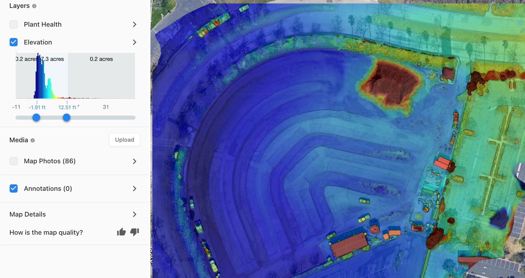
LiDAR
Drones can be equipped with LiDAR (Light Detection and Ranging) sensors, which use lasers to create high-resolution maps of the land. This technology is particularly useful for land development projects that involve complex terrain or structures, such as bridges or tunnels. LiDAR can also be used to detect changes in elevation, which is important for projects that involve grading or excavation.
Environmental Data
Drones can be used to capture a wide variety of environmental data for land development projects, including air and water quality, noise levels, and wildlife populations. This information can be used to identify potential environmental impacts of the project and develop mitigation strategies.

Construction progress monitoring includes orthomosaic images
Construction Monitoring
Aerial Decisions uses drones to monitor construction progress and detect any potential issues that are time sensitive in nature. By capturing high-resolution images and videos of the construction site, we assist developers in identifying potential problems early on and make any necessary adjustments to the project. Additionally, drones can also be used to inspect properties and land without the need for workers to access potentially hazardous areas. This can help to improve safety on job sites and reduce the risk of accidents. Another useful drone application is in the area of on site supply management. Drones can capture volume data for project stockpiles and immediately transfer that data to supply chain managers, ensuring the timely delivery of fresh supplies to each job site.
In conclusion, I can say definitively that drones have become a valuable tool for commercial land development projects. They are capable of capturing a wide variety of data, including aerial and thermal imagery, LiDAR data, environmental data, and construction monitoring data. By using drones to collect this information, developers can make more informed decisions and improve project outcomes.
From The Editor:
Do you need to hire a professional drone service provider? To speak to an aerial data specialist, fill out a form, email us or for even faster response times, give us a call at (833) FLY-4YOU or (833) 359-4968. Check out our transparent pricing at Drone Photography Pricing and watch this space as we expand on the above topics and more over the coming weeks and months. If you like this post, feel free to click the share button at the bottom of the page. We appreciate you helping us by spreading the content we share on our blog.

Founder | CEO at Aerial Decisions
Jim is the founder of Aerial Decisions and is an FAA Part 107 Certified Commercial Drone Pilot.He has spent the last 10 years building and leading world class sales teams for an industry leading digital marketing agency.Jim is widely recognized amongst his peers as a consummate full funnel digital marketing expert and a respected industry leader.
Equally adept as an entrepreneur, Jim has led start up organizations in a multitude of industries ranging from telecommunications to web based software services.In this latest adventure, Jim is leveraging his profound love of flying drones into a dynamic new start-up that he hopes one day becomes the standard bearer for drone flying advocacy across the globe.
Jim originally hails from Clearwater, Florida and currently lives in Glendale, California with his wife Diana and his lovable pup, Gunnar.
When Jim’s not flying drones: “You’ll catch me on the ice (or asphalt) playing beer league hockey or training for my next triathlon.Whether it’s on ice asphalt or in the water you’ll always find me on the move and rarely sitting still.
Latest posts by Jim Gibson (see all)
- How Drones and Reality Data Capture are Transforming Construction Projects - October 11, 2024
- Regulations for Using Drones on Construction Sites in 2024 - August 25, 2024
- What is the Future of Drones in Construction? - August 17, 2024